

Archived Content
In an effort to keep CISA.gov current, the archive contains outdated information that may not reflect current policy or programs.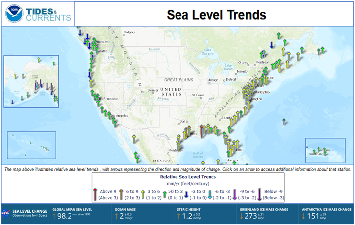
Mean Sea Level: the average base level for coastal areas to measure elevation against the shoreline. Sea level is measured both by tidal gauges and satellites and can be reported as a global average or as local rates.
Sea Level Rise: Changes in mean global sea level, resulting from the transfer of fresh water from land to oceans (from land-based ice sheets and mountain glaciers) and from the thermal expansion of ocean water due to higher global temperatures.
- A Sea Level Rise Study indicated a 100-year storm surge, which is expected to begin occurring every 3–20 years, could cost billions of dollars in direct damages from 1 foot of sea-level rise.
- As more water enters the ocean through melting glacier runoff and thawing permafrost as well as thermal expansion of water under direct heating, the sea level rise will threaten coastal infrastructure and populations.
Moon Wobble: According to NASA, the moon wobble occurs due to the elliptical orbit of the moon that takes 18.6 years to complete. There’s nothing new or dangerous about the wobble; it was first reported in 1728.
- In half of the Moon’s 18.6-year cycle, Earth’s regular daily tides are suppressed: high tides are lower than normal, and low tides are higher than normal.
- In the other half of the cycle, tides are amplified: High tides get higher, and low tides get lower. Global sea level rise pushes high tides in only one direction—higher. So, half of the 18.6-year lunar cycle counteracts the effect of sea level rise on high tides, and the other half increases the effect.
- https://www.nasa.gov/centers-and-facilities/jpl/study-projects-a-surge-in-coastal-flooding-starting-in-2030s/
The higher seas, amplified by the lunar cycle, will cause a leap in flood numbers on almost all U.S. mainland and Pacific island coastlines by the mid-2030s. Only far northern coastlines, including Alaska’s, will be spared for another decade or longer because these land areas are rising due to glacier melt reducing the pressing weight across the surface area.
- A King Tide is a non-scientific term people often use to describe exceptionally high tides. Tides are long-period waves that roll around the planet as the ocean is "pulled" back and forth by the gravitational pull of the moon and the sun as these bodies interact with the Earth in their monthly and yearly orbits.
- Higher than normal tides typically occur during a new or full moon and when the Moon is nearest the Earth, or during specific seasons around the country. https://oceanservice.noaa.gov/facts/kingtide.html
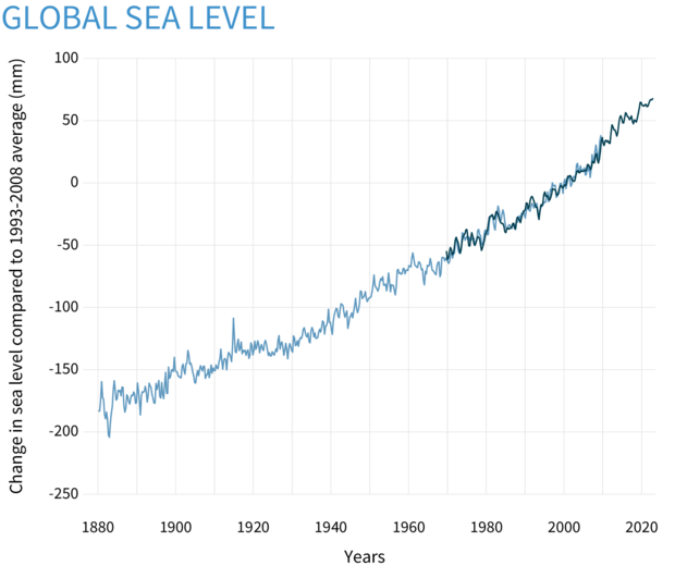
Global average sea level has risen 8–9 inches (21–24 centimeters) since 1880.
- In 2022, global average sea level set a new record high—4 inches above 1993 levels.
- The rate of global sea level rise is accelerating. It has more than doubled from 0.06 inches per year throughout most of the twentieth century to 0.14 inches per year from 2006–2015.
- In many locations along the U.S. coastline, the rate of local sea level rise is greater than the global average due to land processes like erosion, oil and groundwater pumping, and subsidence.
- High-tide flooding is now 300% to more than 900% more frequent than it was 50 years ago.
CISA’s Role in Increasing Sea Level Rise Resiliency
CISA is engaged with the USGCRP to assist in coastal planning for equitable action in planning for communities and critical infrastructure at risk of flooding, erosion, or subsidence in coming decades.
CISA is a contributing member of the Ocean Justice Strategy which outlines overarching goals, principles, and practices that the federal government can adopt in order to provide long-term, sustainable benefits for people, communities, and the environment.
Critical Infrastructure Impacts
Impacts to infrastructure from sea level rise can include flooding, erosion of supporting soils, collapse of buildings, surges of saltwater into waterways, and transportation delays for aviation, ports, roadways, and railways near the coasts. A third of 55 coastal sites in the US will see 100-year storm surges become 10-year or more frequent events by 2050 (NOAA).
Increases in relative sea levels threaten coastal infrastructure, through direct inundation and in combination with storm surge and king tides. Major energy, communication, and transportation centers are located on coastlines, putting their operations and physical safety at risk as sea levels rise.
- Many of the approximately 104 nuclear power plants in the U.S. are situated along the coast due to nuclear plants requiring water for cooling purposes. These facilities and their supporting infrastructure are at risk of damage with rising sea levels.
- In the US, 300 energy facilities are on land at or below 4 feet, including natural gas infrastructure, electric power plants, and oil and gas refineries.
- Ports, docks, bridges, airports, underpasses, dams, roadways, pipelines, and railways all have sea level rise risk from increased floodwater exposure, erosion, and heightened storm surges. Some of the world’s largest ports, such as Houston, are at risk of becoming inoperable by 2050 due to rising sea levels (Reuters, https://www.reuters.com/business/environment/top-global-ports-may-be-unusable-by-2050-without-more-climate-action-report-2023-09-07/)
- Flooding in or near production facilities can cause damage to materials, products, and machinery and could cause delivery delays and disrupted supplies. Flooding causes 90% of disaster damage every year in the U.S. (FEMA, https://www.fema.gov/press-release/20210318/safeguard-your-future-flood-insurance)
- Datacenters in Miami, Ashburn, Philadelphia, Boston, and New York City on the east coast and Los Angeles, San Francisco, Santa Clara, and Seattle on the west coast are some of the largest in the US and are within 80 miles of coastlines at risk of flooding.
- Residential homes and community infrastructure have reportedly fallen into oceans on all US Coastlines over the past five years.
Beyond the facilities, rising sea levels threaten critical infrastructure operations.
- Fiber lit buildings which provide bandwidth capacity (traffic) for end-users and data centers and can be damaged in large flood events.
- Undersea cable landing stations connect submarine cables to land-based power and networking infrastructure located along coasts.
- As seas rise, saltwater is contaminating freshwater aquifers and entering river systems which threatens local water supplies due to salinity surges.
Sea Level Rise Resources and Training
Fifth National Climate Assessment: Coastal Effects
The Fifth National Climate Assessment discusses how climate impacts, including rising sea levels and shifting storm patterns, are transforming coastal landscapes, and undermining the resilience of communities and ecosystems and strategies to adapt.
Explore: Sea Level Rise (noaa.gov)
This portal has tools and services on sea level rise for people to make informed, science-based decisions based on current conditions and future predictions.
NASA Sea Level Change Portal
NASA provides insight on sea levels using satellite imagery and offers a set of climate and data analysis tools that help you to visualize and access sea level information.
Sea Level Rise | US EPA
This page provides the EPA's answers to questions about how much the sea has risen, how much it might rise, and what the impacts might be.
Sea Level Rise | U.S. Climate Resilience Toolkit
Learn about regional variations in sea level rise and forecasted short- and long-term changes.
Coasts, Storms, and Sea Level Rise | U.S. Geological Survey (usgs.gov)
View sea level rise modeling and understand the impacts of sea level rise.
Tutorial for Sea Level Rise Viewer: Local Scenarios (noaa.gov)
Plan for sea level rise inundation in your community by using the local scenarios tab of NOAA's Sea Level Rise Viewer. This self-guided tutorial uses examples to help you understand how to optimize the functionality of the viewer to get the in